CPSH Seminar Series: Kirk Scanlan, Technical University of Denmark
April 29, 2022
May 9, 2022 at 1:00pm CT

Speaker: Kirk Scanlan, Postdoctoral Researcher, National Space Institute, Technical University of Denmark
Host: Cyril Grima
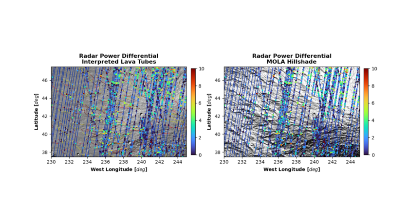
Title: Mapping Buried Martian Lava Tubes through Orbital Radar Sounding
Abstract: Lava tubes occupy a unique position in our ability to understand of the past, current, and future habitability of Mars. Shielded from radiation and micrometeorites, lava tubes represent environments where past extraterrestrial life may best be preserved and where present-day life in the subsurface may be most easily accessible. Into the future, crewed human missions to Mars may look to leverage lava tubes as natural shelters. Taken together, there is therefore a clear need to locate Martian lava tubes and understand their spatial extent.
The conventional way in which Martian lava tubes are identified is by searching for the overhanging shadows and/or diurnal thermal anomalies associated with skylights. However, it is difficult to estimate the full lateral extent of a buried cave system from skylights alone. To this end, spaceborne radar sounding measurements offer a unique surface penetrating capability that has long seemed a powerful, if so far unrealized, contribution to buried lava tube mapping efforts. In this study, we take a new approach inspired by radar sounding studies of features on the bed of the Antarctic Ice Sheet and look leverage the anticipated angular radar scattering extent of buried Martian lava tubes in order to assess their existence. Tested using 107 SHAllow RADar (SHARAD) orbits across the Western flank of Alba Mons, the results show promise in that anticipated radar-derived signals are preferentially observed close to previously interpreted lava tube structures. However, the ability to uniquely identify lava tubes is limited as similar angular radar scattering responses are also produced by other surface landforms such as ridges. Further work is required to refine the approach in other areas of Mars exhibiting less surface topography and the potential for “false” detection can be reduced.
Biography: Kirk Scanlan received his PhD in Geotechnical Engineering in 2018 from the University of Alberta before moving to a postdoc position at the University of Texas Institute for Geophysics. While at UTIG, he worked on NASA’s Europa Clipper mission affiliated with the REASON instrument. He has since moved on from UTIG and is now a postdoc at the National Space Institute at the Technical University of Denmark. In general, his research centers on the data processing and use of radar measurements to address problems across both Earth and planetary science. His on-going research at DTU is in searching out new ways to leverage spaceborne radar altimetry measurements to characterize the near-surface of the Greenland Ice Sheet. When not thinking about radar, he enjoys struggling to learn Danish and exploring Copenhagen with his wife and dog.